
[fusion_builder_container type=”flex” hundred_percent=”no” hundred_percent_height=”no” min_height_medium=”” min_height_small=”” min_height=”” hundred_percent_height_scroll=”no” align_content=”stretch” flex_align_items=”flex-start” flex_justify_content=”flex-start” flex_wrap_medium=”” flex_wrap_small=”” flex_wrap=”wrap” flex_column_spacing=”0px” hundred_percent_height_center_content=”yes” equal_height_columns=”no” container_tag=”div” menu_anchor=”” hide_on_mobile=”small-visibility,medium-visibility,large-visibility” status=”published” publish_date=”” class=”” id=”” margin_top_medium=”” margin_bottom_medium=”” margin_top_small=”” margin_bottom_small=”” margin_top=”” margin_bottom=”” padding_top_medium=”” padding_right_medium=”” padding_bottom_medium=”” padding_left_medium=”” padding_top_small=”” padding_right_small=”” padding_bottom_small=”” padding_left_small=”” padding_top=”” padding_right=”” padding_bottom=”” padding_left=”” link_hover_color=”” hue=”” saturation=”” lightness=”” alpha=”” link_color=”” border_sizes_top=”” border_sizes_right=”” border_sizes_bottom=”” border_sizes_left=”” border_color=”” border_style=”solid” border_radius_top_left=”” border_radius_top_right=”” border_radius_bottom_right=”” border_radius_bottom_left=”” box_shadow=”no” box_shadow_vertical=”” box_shadow_horizontal=”” box_shadow_blur=”0″ box_shadow_spread=”0″ box_shadow_color=”” box_shadow_style=”” z_index=”” overflow=”” background_color_medium=”” background_color_small=”” background_color=”” gradient_start_color=”” gradient_end_color=”” gradient_start_position=”0″ gradient_end_position=”100″ gradient_type=”linear” radial_direction=”center center” linear_angle=”180″ background_image_medium=”” background_image_small=”” background_image=”” skip_lazy_load=”” background_position_medium=”” background_position_small=”” background_position=”center center” background_repeat_medium=”” background_repeat_small=”” background_repeat=”no-repeat” background_size_medium=”” background_size_small=”” background_size=”” background_custom_size=”” background_custom_size_medium=”” background_custom_size_small=”” fade=”no” background_parallax=”none” enable_mobile=”no” parallax_speed=”0.3″ background_blend_mode_medium=”” background_blend_mode_small=”” background_blend_mode=”none” background_slider_images=”” background_slider_position=”” background_slider_skip_lazy_loading=”no” background_slider_loop=”yes” background_slider_pause_on_hover=”no” background_slider_slideshow_speed=”5000″ background_slider_animation=”fade” background_slider_direction=”up” background_slider_animation_speed=”800″ background_slider_blend_mode=”” video_mp4=”” video_webm=”” video_ogv=”” video_url=”” video_aspect_ratio=”16:9″ video_loop=”yes” video_mute=”yes” video_preview_image=”” pattern_bg=”none” pattern_custom_bg=”” pattern_bg_color=”” pattern_bg_style=”default” pattern_bg_opacity=”100″ pattern_bg_size=”” pattern_bg_blend_mode=”normal” mask_bg=”none” mask_custom_bg=”” mask_bg_color=”” mask_bg_accent_color=”” mask_bg_style=”default” mask_bg_opacity=”100″ mask_bg_transform=”left” mask_bg_blend_mode=”normal” render_logics=”” logics=”” absolute=”off” absolute_devices=”small,medium,large” sticky=”off” sticky_devices=”small-visibility,medium-visibility,large-visibility” sticky_background_color=”” sticky_height=”” sticky_offset=”” sticky_transition_offset=”0″ scroll_offset=”0″ animation_type=”” animation_direction=”left” animation_color=”” animation_speed=”0.3″ animation_delay=”0″ animation_offset=”” filter_hue=”0″ filter_saturation=”100″ filter_brightness=”100″ filter_contrast=”100″ filter_invert=”0″ filter_sepia=”0″ filter_opacity=”100″ filter_blur=”0″ filter_hue_hover=”0″ filter_saturation_hover=”100″ filter_brightness_hover=”100″ filter_contrast_hover=”100″ filter_invert_hover=”0″ filter_sepia_hover=”0″ filter_opacity_hover=”100″ filter_blur_hover=”0″][fusion_builder_row][fusion_builder_column type=”1_1″ layout=”1_1″ background_position=”left top” background_color=”” border_color=”” border_style=”solid” border_position=”all” spacing=”yes” background_image=”” background_repeat=”no-repeat” padding_top=”” padding_right=”” padding_bottom=”” padding_left=”” margin_top=”0px” margin_bottom=”0px” class=”” id=”” animation_type=”” animation_speed=”0.3″ animation_direction=”left” hide_on_mobile=”small-visibility,medium-visibility,large-visibility” center_content=”no” last=”true” min_height=”” hover_type=”none” link=”” border_sizes_top=”” border_sizes_bottom=”” border_sizes_left=”” border_sizes_right=”” first=”true”][fusion_global id=”8834″][fusion_text columns=”” column_min_width=”” column_spacing=”” rule_style=”” rule_size=”” rule_color=”” hue=”” saturation=”” lightness=”” alpha=”” user_select=”” awb-switch-editor-focus=”” content_alignment_medium=”” content_alignment_small=”” content_alignment=”” hide_on_mobile=”small-visibility,medium-visibility,large-visibility” sticky_display=”normal,sticky” class=”” id=”” width_medium=”” width_small=”” width=”” min_width_medium=”” min_width_small=”” min_width=”” max_width_medium=”” max_width_small=”” max_width=”” margin_top=”” margin_right=”” margin_bottom=”” margin_left=”” fusion_font_family_text_font=”” fusion_font_variant_text_font=”” font_size=”” line_height=”” letter_spacing=”” text_transform=”” text_color=”” animation_type=”” animation_direction=”left” animation_color=”” animation_speed=”0.3″ animation_delay=”0″ animation_offset=”” logics=””]
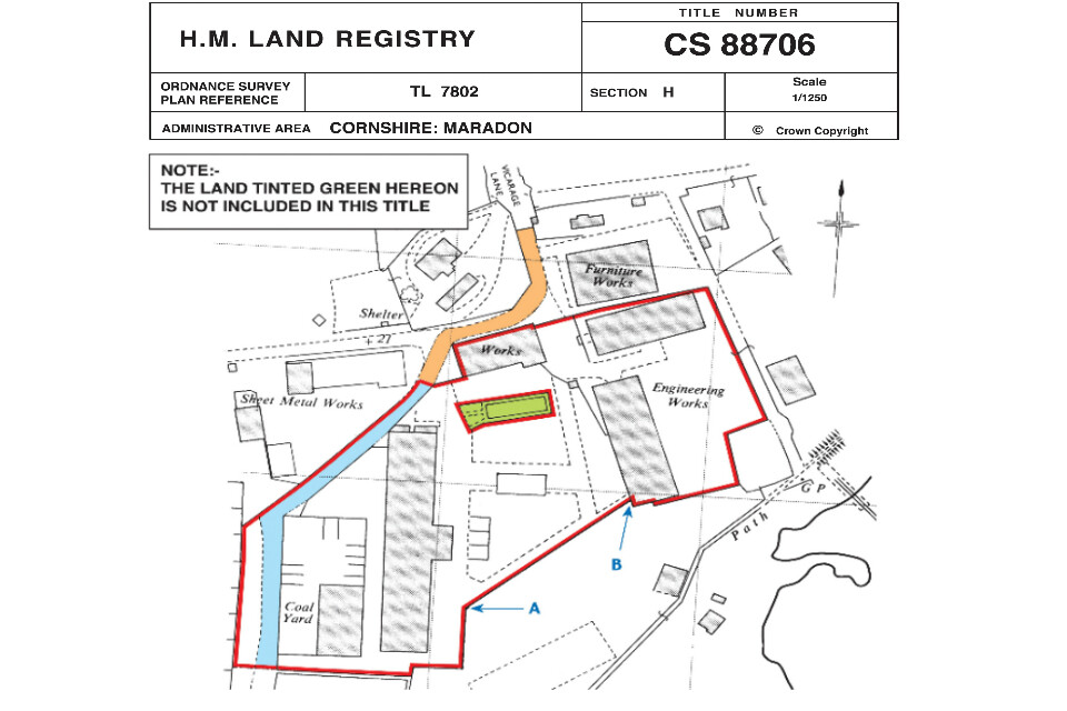
When a piece of land is registered with HM Land Registry a document called a title plan is created.
The title plan shows the registered piece of land and is created alongside another document, called the title register, also known as its office copy entries, which contains information about the property, including its ownership status.
The title plan, which was previously and is still sometimes referred to as the filed plan, supports this description pictorially.
Using extracts from ordinance survey maps this shows the location and approximate boundaries of the property.
Each property is given a unique reference number called its title number, which connects the title plan and the title register, as well as the other documents which together make up its title deeds.
[/fusion_text][fusion_text columns=”” column_min_width=”” column_spacing=”” rule_style=”” rule_size=”” rule_color=”” hue=”” saturation=”” lightness=”” alpha=”” user_select=”” awb-switch-editor-focus=”” content_alignment_medium=”” content_alignment_small=”” content_alignment=”” hide_on_mobile=”small-visibility,medium-visibility,large-visibility” sticky_display=”normal,sticky” class=”” id=”” width_medium=”” width_small=”” width=”” min_width_medium=”” min_width_small=”” min_width=”” max_width_medium=”” max_width_small=”” max_width=”” margin_top=”” margin_right=”” margin_bottom=”” margin_left=”” fusion_font_family_text_font=”” fusion_font_variant_text_font=”” font_size=”” line_height=”” letter_spacing=”” text_transform=”” text_color=”” animation_type=”” animation_direction=”left” animation_color=”” animation_speed=”0.3″ animation_delay=”0″ animation_offset=”” logics=””]
In this Guide
[/fusion_text][fusion_text columns=”” column_min_width=”” column_spacing=”” rule_style=”” rule_size=”” rule_color=”” hue=”” saturation=”” lightness=”” alpha=”” user_select=”” awb-switch-editor-focus=”” content_alignment_medium=”” content_alignment_small=”” content_alignment=”” hide_on_mobile=”small-visibility,medium-visibility,large-visibility” sticky_display=”normal,sticky” class=”” id=”” width_medium=”” width_small=”” width=”” min_width_medium=”” min_width_small=”” min_width=”” max_width_medium=”” max_width_small=”” max_width=”” margin_top=”” margin_right=”” margin_bottom=”” margin_left=”” fusion_font_family_text_font=”” fusion_font_variant_text_font=”” font_size=”” line_height=”” letter_spacing=”” text_transform=”” text_color=”” animation_type=”” animation_direction=”left” animation_color=”” animation_speed=”0.3″ animation_delay=”0″ animation_offset=”” logics=””]
01 | What is the purpose of a Title Plan?
A title plan is created to support the description of a property given in the title register by providing a graphic illustration showing the properties general extent and location. The plan will be ordered by your solicitor as they begin collecting documents as part of the conveyancing task.
On top of showing the land under a registered title, the title plan also indicates which parts of the land or adjacent land are affected by any covenants or easements.
02 | What does a Title Plan show?
The first thing you will find on a title plan is an image taken from a map showing the property in question.
You will also find the title number of the land. This will be something like TGL654321.
The image is taken from an Ordinance Survey map and will have an associated scale. There will be a reference to which OS map was used to prepare the title.
Generally, title plans are drawn at a 1:1250 scale in urban areas, and 1:2500 scale in rural areas.
Title plans are based on the ordinance survey map which was current at first registration. This means they will often be outdated. This means they do not include new buildings, or those that have been since demolished.
The land included in the title will be highlighted by a black line highlighted in red.
If a physical feature, like a fence or a hedge, marks the boundary the black line will be solid, while if it is unmarked it will be dashed.
Any exclaves, or separate pieces of land included in a property will be hatched in green, in addition to being surrounded by a red line.
If there are other coloured markings on the title plan you should refer to the title register. There will be a section which explains their individual significance.
03 | A Title Plan example
Here is an example of a title plan showing these are marked:
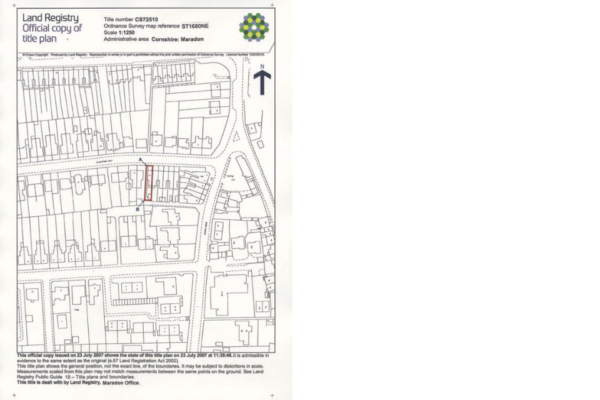
Colours other than red are often used to show the areas affected by easements and covenants.
04 | Can I rely on the boundaries shown on a Title Plan?
A title plan should show the approximate area covered by its associated property.
However, the plans are not always accurate. In fact all title plans carry the following warning against using them when mapping out boundaries:
“This title plan shows the general position of the boundaries: it does not show the exact line of the boundaries.
“Measurements scaled from this plan may not match measurements between the same points on the ground.”
Errors may enter the title plans as they do not define boundaries, but rather are created to show them.
This is because title plans in England and Wales use the general boundary system.
While precise legal boundaries do exist, they are often unknown and can sometimes be difficult to define.
Therefore, precise legal boundaries are very rarely included on title plans.
When the Land Registry shows a boundary on a title plan, they are telling you the legal boundary is nearby, at an unknown distance and not exactly parallel to the marked boundary.
The general boundaries do not show who owns any physical boundary barriers, like fences, walls, or hedges.
Often more information about a particular property’s boundaries can be found in documents contained in its title deeds.
If you would like to learn more about boundary law the Jon Maynard Boundaries Limited website Boundary Problems is an extensive if slightly dated fount of knowledge.
05 | How can I get a copy of my Title Plan?
You can order a copy of your title plan online from HM Land Registry. This will cost you £3.
To order a copy you must create an account on the Land Registry website and pay with a credit or debit card.
Anyone can order the title plan for any property provided they know the postcode and street address.
You do not need the owner’s permission to buy a copy of a property’s title plan from the Land Registry.
You can also order a copy of the title register, which will confirm an up-to-date snapshot of any restrictive covenants which apply to a property.
06 | Vector Title Plans vs Raster Title Plans
Vector title plans are created using a computer mapping system and electronically stored. All newly created title plans are made this way.
Raster title plans are electronically stored images of what was previously a paper plan.
Historically, all title plans were in paper form, although the majority have now been digitised.
The only exceptions to this are drawer/canister plans which were too large to be scanned. You will almost never encounter one of these when dealing with normal residential property. If you do come across these they can make for very interesting historical reading.
07 | What is a Lease Plan?
A lease plan is a scaled drawing that shows how a leasehold property is split up.
It will show the land or part of a building where a lessee (or tenant) has exclusive or shared access. They can often take the form of a floor plan.
The private part of a leasehold property will be show outlined in red, while common areas will be outlined in green.
Lease plans have been a legal requirement since the Land Registration Act 2002 came into effect.
08 | Should I check the Title Plan when buying a property?
Yes!
If you are buying a property, you should compare its physical boundaries with those shown on the title plan.
Checking this will ensure that you end up purchasing what you are expecting.
Any land not enclosed in red is not part of the property. Common issues that can arise include garages, parking spaces, and gardens, as well as separated plots of land.
You should check that all of these are outlined in red on the title plan.
If you spot any issues, you should bring these to your conveyancer’s attention immediately.
Enquiries can then be made of the seller to see if the land belongs to the selling party. If it does not, the value of the property could then be called into question.
Always sort out this kind of problem before exchanging contracts. Even if this causes a delay, it is better to sort it out before committing to a property.
Conclusion
A title plan shows a properties general location and boundaries, as well as areas affected by covenants and easements.
It is an important document to check when buying a property. While the boundaries shown upon it are not exact, they can give you a good idea of what you are buying.
Often, more exact details about a property’s boundaries can be found elsewhere in its title deeds. This can be useful when determining who is responsible for boundary maintenance.
Has this article been helpful? Let us know by leaving a short comment below.[/fusion_text][fusion_global id=”8979″][fusion_global id=”8540″][/fusion_builder_column][/fusion_builder_row][/fusion_builder_container]